

The use of GPS and cell phones now makes finding oneself around a strange city simple and quick. You can punch in an address and whether on foot, bicycle, or in an auto, you get exact directions to get where you want to go. However, it wasn’t so long ago people got by with the help of the Earth’s magnet field, a map, and a Lensatic compass.
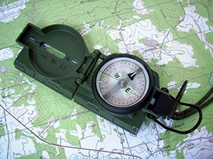
How To Use A Lensatic Compass
Before GPS, There Was The Lensatic Compass
 The military used a Lensatic compass in WW II to find their way from the beachhead’s all the way to Berlin. It wasn’t until just a few years ago when they started integrating GPS into the individual military units and even missiles now use GPS to locate their targets with pinpoint accuracy.
However, any GI or Marine worth their salt still knows how to read a compass and a map. Civilians are still buying them for orienteering, camping, and hiking. Preppers, outdoorsman, and survivalists also carry a Lensatic compass when they hit the wilds because a compass cannot be affected by rain, wind, and loss of battery power.
In all these cases, it could be said that GPS is better and more accurate. But a Lensatic compass will work night or day and is there if the satellites that run the GPS system are shut down in the event of war or major catastrophe that disrupts worldwide cellular communications.
Not, That It Could Possibly Happen… Or Could It?
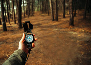
But, in any case, today you are about to get a crash course in how to use a Lensatic compass to help you learn to be self-reliant. The knowledge increases your ability to exist in the wild away from cell towers and with only a map and your compass, navigate your way to your destination or find your way back home.
There’s More Than One To Use A Map Virginia
To use a Lensatic Compass, you know where your starting point is, and then you sight on a landmark that you line up with a bearing that matches the direction or location you want to go.
You can get highly accurate maps of almost any place in the world designed to work with a Lensatic Compass. The US Geological Survey maintains all the maps for the world. Topographical maps can be ordered from their site.
However, many bookstores and natural history museums carry them. The Field Museum at one time also had them available for sale as well.
With these or orienteering maps you can find yourself within a square couple of meters or so. These then enable you to get from point A to B with little or no difficulty.
Now for a bit more detailed use and showing rather than telling we go to the next section.
To Use A Compass Well Means You’ll Never Be Lost, And You Will Always Be Where You Are
A detailed manual on using a Lensatic Compass can be found here for you to download and study with the help of the website, Survival Primer.
It teaches you the basics you need to become an efficient land navigator.
You might want to get more info on your compass from this video.
For those of you who still know how to align yourself on a map. The easiest way this writer uses is to imagine that he is standing on the map and after aligning it with North then can move around like in one of those war games that the Table Gamers play.
 One of the great problems is the fact is that Magnetic North and True North are not the same. So, you need to correct this, and you can use this video to learn more about it.
It becomes acuter if you are down under. Therefore, here is the Australian take on the topic.
Here they talk about the Military Grid Map System, which your maps may or may not be using. It is worth taking a look at, as many military maps use this system.
Because of its design, it does not point to True North. Therefore, you need to be aware of this.
But, if all that we’ve covered so far hasn’t boggled your mind yet, here is perhaps one of the simplest ways to get things done without any muss or fuss.
Choosing is a good compass is crucial and here are 10 that will give you some idea of what to look for.
All of the above is just to get your feet wet on the topic of land navigation with a Lensatic Compass. We now go to the ultimate guide that for decades has been the bible on the topic.
FM 3-25.26
The Army has the distinction of having one of the best guides on the topic anywhere and it is freely downloadable by anyone. In fact, this is one of the many manuals popularly downloaded by the People’s Republic of China as well. This is strange as our Army’s manuals are freely downloadable there and they translate them into Mandarin and read them in English as well. If you think, we are kidding, look for yourself.
However, you can get yourself a copy without having to get it from China.
This is a 200+ page manual that gives you the whole ball of wax and you get the skinny on Maps, overlays, and how to apply the knowledge in an urban setting, the desert, jungle, and even in the Arctic regions that and many other topics are explored.
Were you aware that there is a prescribed method for folding your map? Well, there is and of course, they go into the proper use of GPS as well. So, you get the whole kit and caboodle in one manual.
The language is dry and gets a bit technical in places but it has been taught to millions of service folk as well as uncounted others in other countries as well. To go along with this manual you can also get a set of flashcards to help you memorize your lessons.
The Marines have parred the massive tome down to their needs and you can look at this little gem as well.
Final Thoughts
In today’s article, you now have the rudiments of how to use a Lensatic Compass. With them and a good map, you can hike in the wilderness and enjoy nature without staring down at your iPhone, smartphone, and portable GPS unit. Devices, which require batteries, clear signal, and nothing to block the satellite.
With a Lensatic Compass and the know-how, you have gained today, you can become a “Landmaster” in a short period of time. Some have gotten it down in a couple of days and others take a bit longer. Nevertheless, using a compass and map should be a basic skill for anyone who travels today, Whether or not they use GPS.
Many today, cannot even use a road map to travel the Interstates nowadays. What would happen if your car breaks down along one of those long stretches of road in the boonies? Well, you can find the nearest ranger station, source of freshwater, and even emergency caches that are placed strategically around the country to help stranded travelers and hikers.
But, you cannot make use of any of this information unless you can read a map and navigate from where you are to where safety lies.
However, now you can and have the peace of mind knowing you can travel no matter what to wherever you want and anytime you want.